- 01 September, 2024
 Foreign Affairs, Geopolitics & National Security
Revealed: China Bolstering Its Military Might In South China Sea
Gp Capt Arvind Pandey (Retd)
Fri, 05 May 2023
| Reading Time: 5 minutes
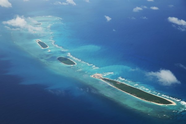
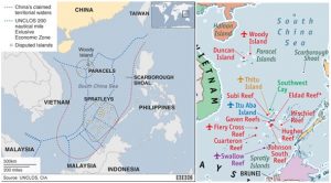
The South China Sea is considered to be one of the busiest waterways in the world and is a significant gateway for trade and merchant shipping. The South China Sea disputes are maritime and island claims between different sovereign states in the region. The countries’ party to these disputes are China, Brunei, Taiwan, the Philippines, Vietnam, and Malaysia and are geopolitically located in the Indo-Pacific region. The regions of contention are mainly the Spratly Island and the Paracel Island.
The reason why these areas are disputed and of interest to the concerned nations is the acquisition of fishing areas around the two archipelagos; suspected crude oil and natural gas in different parts of the South China Sea; and the control of strategically important shipping lanes. Beijing has developed at least seven artificial islands, creating 1,295 hectares (3,200 acres) of new land since 2013, according to the CSIS Asia Maritime Transparency Initiative.
Recent Revelations
In a recent acquisition of aerial images, Filipino photographer Ezra Acayan obtained access to flights covering Spratly Islands, near a number of reefs and rocks that China has reclaimed and turned into military bases with radar stations, airstrips and artillery installations. The images are with some of the most detailed elements of what China is up to there and they give a totally new perspective compared to the daily satellite images available in open domain. These images provide extensive details of the People’s Liberation Army (PLA) facilities on Mischief Reef, Gaven Reefs, Subi Reef, Cuarteron Reef, Fiery Cross Reef and Hughes Reef – six of the 15 Spratly features occupied by China. In this article elements related to military importance have been articulated.
The image of Fiery Cross shows, a KJ-500 airborne early warning and control aircraft is visible on the runway. It is known that KJ-500 and other similar intelligence-gathering and submarine-hunting aircraft frequently operate from the airfield at Fiery cross and other runways in vicinity.
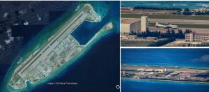
Fiery Cross Reef
Image of Cuarteron Reef shows naval gun emplacements on adjacent multiple ground entities of increasing height, and ending with setup of a large radar radome. It is understood that radar’s elevated position gives a better line of sight for surveillance. These types of weapon installations are common to these island outposts which would provide limited area defence against low-flying air threats, like aircraft and drones. Nearby adjacent to another radome structure, truck-mounted phased array radar is also visible with other supportive elements which are covered with camouflaged garnishing.
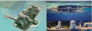
Cuarteron Reef
The image of Mischief Reef shows full sized runway with other details. An aircraft can be seen inside the open hangar at the top of the image, which is difficult to identify but most probably it is like a Y-8/9 or another four-engine turboprop aircraft. The picture of Mischief Reef notably shows a pair of Type- 022 Houbei class catamaran fast attack missile craft, readily recognisable by their distinct camouflage scheme. The first reports that the People’s Liberation Army Navy had deployed Type 022s to this outpost emerged last year. These boats are relatively small, but can carry surface to air missiles, anti-ship missiles, along with their bow-mounted 30mm H/PJ-13 Gatling-type guns.
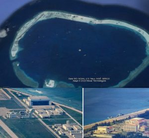
Mischief Reef
The image of Subi Reef shows, movable obstacles like military vehicles were positioned on the runway and parallel taxi track, for denial of landing of any other aircraft on the island. This also shows military nature of the use of runway.
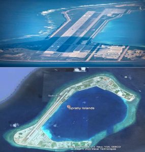
Subi Reef
Developments in Recent Times
China has been in constant push to create a near-seamless anti-access/area-denial bubble covering almost the entire South China Sea. Building such extensive infrastructure on these manufactured portions of land is a key part of that plan. Apart from short-range weapons like the naval guns visible in these pictures, China has deployed longer-range systems to some of these islands. Clearly, their infrastructure was designed to help conceal these mobile systems when not in use or not on high alert and they could pour in additional capabilities with little notice.
Beijing has aggressively asserted its claim to these and other disputed shoals in the South China Sea. By artificially expanding some existing islands, building new ones, and establishing a permanent military presence, China seeks to solidify these claims, regardless of what the international community or its neighbours think of them. This year alone, China has increased its defence spending by 7.1 per cent, making its defence budget the second largest in the world.
Militarisation of Archipelago
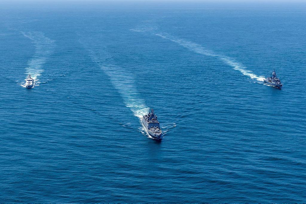
As outlined in the newly published National Defence Strategy, the U.S. military considers China the pacing threat as it contemplates potential future conflict. Each U.S. military service is preparing to operate across the vast distances of the Pacific as it challenges Chinese expansionism in the region. The U.S. Navy also takes responsibility for maintaining freedom of navigation through the contested South China Sea, often steaming carrier strike groups and other ships, along with those of allies and partner nations, through the area and within sight of Chinese naval vessels. This has led to some very tense maritime encounters.
Recently U.S. Indo-Pacific commander Admiral John Aquilino said the U.S. had intelligence that China had fully militarised three islands in the South China Sea. He cited it as the “largest military build-up since World War II by the PRC (People’s Republic of China)”. These images acquired via aerial imaging strengthen the perceptions relating to militarisation of South China Sea.

Disclaimer
The opinions expressed in this article are the author’s own and do not reflect the views of Chanakya Forum. All information provided in this article including timeliness, completeness, accuracy, suitability or validity of information referenced therein, is the sole responsibility of the author. www.chanakyaforum.com does not assume any responsibility for the same.
Chanakya Forum is now on . Click here to join our channel (@ChanakyaForum) and stay updated with the latest headlines and articles.
Important
We work round the clock to bring you the finest articles and updates from around the world. There is a team that works tirelessly to ensure that you have a seamless reading experience. But all this costs money. Please support us so that we keep doing what we do best. Happy Reading
Support Us Or


9289230333
Or


POST COMMENTS (0)