
- 27 July, 2024
 Foreign Affairs, Geopolitics & National Security
India’s Military Satellites: The Armed Forces’ Bulwarks For Communication & Surveillance!
Brig Arvind Dhananjayan (Retd)
Mon, 17 Apr 2023
| Reading Time: 8 minutes
The Indian Land Forces’ pursuit for a dedicated orbital communications platform is finally seeing fructification. In order to equip the Indian Army (IA) with a dedicated advanced communications satellite, the Ministry of Defence has just last month inked a Rs. 2963 Crores contract with New Space India Limited (NSIL), the commercial arm of the Indian Space Research Organisation (ISRO), for development of the Geostationary Satellite (GSAT)-7B. The GSAT-7B is envisaged to provide high throughput* communication services, and in doing so, manage intra and inter Service communications for the IA in a Network Centric Warfare (NCW) environment.
* Bandwidth and throughput are two terms related to network performance. Network bandwidth defines how much data can possibly travel through a network in a period of time. Network throughput refers to how much data actually transfers during a period of time. These terms would therefore define the efficiency of a communications network /node/communications platform.
The signing of this red-letter contract comes exactly a year after India’s Defence Acquisition Council (DAC) granted Acceptance of Necessity (AoN) for the GSAT-7B under the Buy Indian (Indigenously Designed, Developed and Manufactured-IDDM) category of the Defence Acquisition Procedure (DAP)- 2020, another concrete step in India’s march towards self-reliance in Defence. This is reportedly the result of a proposal mooted by the IA post a study of network-centric as well as standalone cyber, communications and electronic warfare systems deployed in the Russia-Ukraine war, which established the imperativeness of robust and secure satellite communications to link forces deployed in the tactical battle area with their headquarters stationed in the hinterland. Undoubtedly, the IA’s stand-offs with the Dragon in the recent past have catalysed this requirement.
The GSAT-7B, likely to be deployed by 2026, will be the first-ever indigenously designed, developed and manufactured satellite in the five-ton category and will bolster beyond-visible-horizon communication for the IA. The GSAT-7B will boast strong electronic and communications security features, in order to provide a backbone for a plethora of IA’s communication needs- from tactical communication support to deployed troops and surveillance/ targeting control of remotely piloted aircraft, to Air Defence platforms, as well as operational communications between Formation Headquarters and strategic inter-Service communications for the IA. The dedicated communication links provided by the satellite will also serve to reduce the input to decision time in respect of the IA’s surveillance network, thus enabling responsive surveillance along India’s borders as well as in the hinterland. The GSAT-7B will provide the IA with the following advantages:-
- Improved capability of the IA for NCW/ communication survivability in a digitised and intense Electronic Warfare environment.
- Redundancy in tactical and backbone strategic communications for the IA, which would prove specifically advantageous in manoeuvre and airborne operations where large inter-se distances are likely to be involved; as also in offensive and defensive operations over high-altitude/ rugged terrain along most of the Line of Control with Pakistan and Line of Actual Control with China, where line-of-sight communications are severely degraded. This would also extend to improvement in deployment/ reaction timings, as would assume importance in the wake of incidents like the Doklam stand-off and subsequent developments, which have led to amorphous deployment lines. Such redundancy in communications would also prove imperative against the spectre of a collusive, multi-border threat.
- Would improve the IA’s operational efficiency in counter-insurgency/ counter-terrorism operations in Jammu & Kashmir and the North-Eastern States as well as in the peninsular hinterland.
- Boost the operational efficiency of unmanned aerial vehicles by enhancing ranges with secure communication data links.
- Improve the response of the IA and affiliated para-military forces to Humanitarian Aid & Disaster Relief tasks.
- Enhanced communication efficiency in routine functioning of headquarters, deployed units and static organisations of the IA.
The above does not however imply that the IA and its sister Services have been bereft of such communications support presently or in the past.
The GSAT-7 (INSAT [Indian National Satellite System]-4F) Series of military communication satellites was kickstarted with the launch of ISRO’s first dedicated, multi-band military communications satellite (Rukmini) in August 2013, for use by the Indian Navy (IN), to monitor the Indian Ocean Region (IOR). The 2650 Kg satellite, with a project cost of Rs. 950 Crores, was put in orbit by the European Space Agency’s Ariane Heavy Lift Space Launch Vehicle, launched from the Guiana Space Centre in French Guiana. The satellite was tailor-made for its communications (and surveillance) role due to its large swathe exceeding 3000 Km and its ability to provide real-time inputs to the IN’s surface/subsurface fleets and shore-based communications setups. The satellite thus extended the IN’s blue water capability into the IOR and ended the IN’s continued reliance on foreign satellites, like UK’s INMARSAT. GSAT-7 was reportedly able to seamlessly network close to about 150 ships and aircraft during the Theater-level Readiness and Operational Exercise (Tropex), held in 2014 in the Bay of Bengal (Source-Wikipedia), thus vindicating its capabilities. The envisaged life of the satellite was seven years, which it has successfully exceeded by remaining operational for more than nine years. As a replacement for the GSAT-7, the IN has requisitioned an upgraded military communications satellite, GSAT-7R, in June 2019, at a projected cost of approximately Rs. 1600 Crores. The satellite is projected to be launched this year.
In further demonstration of India’s ever-strengthening self-reliance resolve, the GSAT-7A (Angry Bird), an advanced military communications satellite for use by the Indian Air Force (IAF), was launched on 19 December 2018 aboard an indigenous Geosynchronous Satellite Launch Vehicle (GSLV) Mark II F-11 Rocket from the Satish Dhawan Space Center (SDSC) at Sriharikota. The 2250 Kg satellite has a mission life of 8 years and is equipped with multiple Ku band transponders, thus offering several advantages like more powerful satellite uplink/ downlink signals and non-interference with terrestrial microwave systems. Apropos, the satellite has since boosted the NCW capabilities of the IAF by providing seamless real-time communications support to the IAF’s fighter fleet, ground radar stations, operational bases and own Airborne Early Warning and Control System platforms. 30% of the satellite’s transponder bandwidth is also being used by the IA, which includes Army Aviation helicopters and UAVs. The DAC had also accorded AoN in November 2021 for the development of GSAT-7C along with ground hubs at a cost of Rs. 2236 Crores to facilitate beyond line-of-sight connectivity of the IAF’s software-defined radios (SDRs- radios that rely on digital algorithms instead of analogous circuits for functioning, thus enjoying higher imperviousness to jamming).
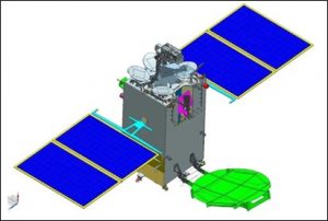
GSAT-7A:Source-isro.gov.in
In addition to the above dedicated military satellites, the Indian Armed Forces have been subscribing to inputs from a plethora of satellites intended primarily for civilian use. Some of these which are presently active/ were launched with a unique mission profile are enumerated below:-
- RISAT Series. The Radar Imaging Satellite (RISAT) series are all-weather Earth Observation (EO) satellites developed by ISRO, which have military applications of surveillance and reconnaissance in addition to employment in the fields of disaster management and agriculture. They mount a Synthetic-Aperture Radar (SAR), the use of which obviates any obfuscation by cloud cover that adversely affected previous optical and spectral sensor satellites. The launch of RISAT-2 (second satellite of the series) was expedited ahead of RISAT-1 in April 2009, in the wake of the 2008 Mumbai terror attacks, with an Israeli Aerospace Industries X-Band SAR. The satellite was used for border surveillance, anti-infiltration and anti-terrorist operations and was deactivated in October 2022. RISAT-1 was launched in April 2012, with an indigenous C-Band SAR with a resolution of 3 to 50 m. It supported a spotlight mode for prolonged 1 m resolution focus on a given geographical area. The satellite was decommissioned in March 2017. RISAT-2B, launched in May 2019 from SDSC, is the third satellite in the series and mounts an indigenous X-Band radar. The satellite is used for obtaining high-resolution spot images of the order of 0.5 x 0.3 m resolution and has a mission life of five years. RISAT-2BR1 was launched on 11 December 2019 from SDSC. This satellite also has a mission life of five years and is for similar use, with a resolution of just 0.35 m.

Screengrab of Video Showing Deployment of Radial Rib Antenna of RISAT-2BR1 In Space (Inset- RISAT-2BR1): Source-isro.gov.in
- EMISAT. India’s first Electromagnetic Intelligence Gathering Satellite (EMISAT), developed by ISRO, was launched in April 2019 through a Polar Satellite Launch Vehicle (PSLV) from SDSC. The satellite is equipped with DRDO’s Electronic Intelligence (ELINT) package Kautilya, allowing it to carry out scanning of the electromagnetic spectrum. The capabilities include, but are not limited to, space-based Electronic Intelligence (ELINT) for enhancing situational awareness of the Indian Armed Forces and carrying out direction-finding/location of ground-based radar systems of potential adversary countries. The Ka-Band frequency of the satellite allows it to scan through inclement weather and various terrain configurations with ease. This satellite also has an envisaged mission duration of five years.
Schematic Representation of EMISAT in Deployed Configuration: Source-Wikipedia
- Cartosat-2E. This optical EO satellite, as part of the Indian Remote Sensing Program (the largest constellation of remote sensing satellites for civilian use in operation today in the world!), is designed to collect high-resolution, large-scale imagery, has civilian applications in the field of urban/ utilities planning, infrastructure development and traffic management. The satellite can also provide higher-resolution images in the visible and near-infrared spectrum down to 0.6 m2, as well as short videos, for military use. Known as the ‘eye in the sky‘, the Cartosat-2E was launched by ISRO in June 2017 from SDSC and is presently on extended mission life.
- Hyperspectral Imaging Satellite (HySIS). HySIS is another EO satellite developed by ISRO and launched from SDSC on 29 November 2018. It provides India with Hyperspectral Imaging pertaining to agriculture, forestry, coastal zones, and inland waterways. Certain objects leave unique ‘fingerprints’ in the electromagnetic spectrum. Known as spectral signatures, these ‘fingerprints’ enable identification of the materials that make up a scanned object. Hyperspectral Imaging refers to the ability to discern fine wavelengths beyond the visible spectrum, including the electromagnetic spectrum, thus allowing the capture of high-resolution sensory images over a wide range of wavelengths. HySIS covers wavelengths in the visible near-infrared and shortwave infrared range, with a spatial resolution of 30 m and a swathe of 30 km from its 630 km high sun-synchronous orbit (referring to a polar orbit which passes over the same geographical location at the same local mean solar time). HySIS inputs are also available to the Indian Armed Forces for surveillance, reconnaissance (to determine suitable deployment areas) and change-detection (viz changes in adversary’s force deployments) over designated geographical areas. This satellite also has an envisaged (extendable) mission duration of five years.
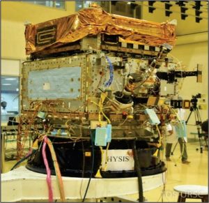
HySIS: Source-isro.gov.in
- Microsat-R. This satellite was stated to be a dedicated Defence experimental imaging satellite by its manufacturer, DRDO. It was launched on 24 January 2019 from SDSC. It later uniquely served as a target during India’s anti-satellite (ASAT) weapon test- Mission Shakti (read more @ https://chanakyaforum.com/asat-systems-space-weaponization-a-boon-or-bane/ and https://chanakyaforum.com/indias-ballistic-missile-interceptors/ ). This test made India only the fourth country in the world- behind the United States, Russia and China – to develop and test an ASAT weapon!
Conclusion
The provisioning of dedicated military satellites for all three Services of the Indian Defence forces, with planned future redundancies, indicates the focus for, and priority accorded to, enhanced operational efficiency well into the 21st century. In an epitome of holistic development, the GSAT-7B and future projects will also aim towards generating substantial employment for personnel within the Defence PSUs, Micro Small and Medium Industries as well as for associated startups- a true saga in self-dependence in cutting-edge Defence technology!

Disclaimer
The opinions expressed in this article are the author’s own and do not reflect the views of Chanakya Forum. All information provided in this article including timeliness, completeness, accuracy, suitability or validity of information referenced therein, is the sole responsibility of the author. www.chanakyaforum.com does not assume any responsibility for the same.
Chanakya Forum is now on . Click here to join our channel (@ChanakyaForum) and stay updated with the latest headlines and articles.
Important
We work round the clock to bring you the finest articles and updates from around the world. There is a team that works tirelessly to ensure that you have a seamless reading experience. But all this costs money. Please support us so that we keep doing what we do best. Happy Reading
Support Us Or


9289230333
Or


POST COMMENTS (0)