- 27 July, 2024
 Foreign Affairs, Geopolitics & National Security
Indian Regional Navigational Satellite System (IRNSS)
Dr PVGS Jayaram
Wed, 07 Jun 2023
| Reading Time: 5 minutes
“On 29th May 2023, ISRO successfully launched the GSLV-F12 NVS-01 mission, deploying the second-generation NavIC satellite into space. The NVS-01 satellite is the first of the new series aimed at enhancing the Navigation with Indian Constellation, NavIC services. After a flight of about 19 minutes, the 2232kg NVS-01 satellite was injected precisely into a Geosynchronous Transfer Orbit.”
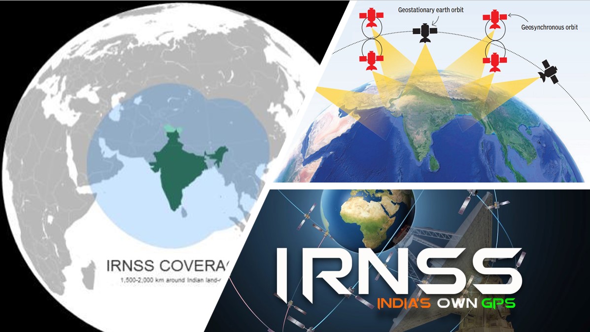
The Indian Regional Navigation Satellite System (IRNSS), also known as Navigation with Indian Constellation (NavIC), is India’s indigenous satellite navigation system developed by the Indian Space Research Organisation (ISRO). Indian strategic, military, and commercial equipment mostly receive Positional, Navigational and Timing (PNT) signals from NAVSTAR GPS with redundancy established from GLONASS constellation operating in L-band. It is well established that L- Band navigational signals are prone to Jamming/ Spoofing. In order to ensure uninterrupted availability of PNT signals, Indian systems receive signals from both GLONASS and GPS besides receiving GPS augmentation signals from GAGAN and field DGPS corrections.
IRNSS/ NavIC has been operational for over 5 years and the stabilisation of PNT signals have now been integrated with the existing systems in India, with industry coming forward with different forms of receivers. The much-desired migration to IRNSS is inevitable, with assured supply of receivers to all the stakeholders. Ministry of Road Transport and Highways (MORTH) has already issued directions through Gazette notification and DGCA has issued necessary directives to migrate compulsorily to NavIC in their respective areas of domain. The migration to IRNSS is necessary for the Armed Forces and Indian commercial entities at large. Some of the reasons are listed out as under: –
- The coverage of other GNSS constellations suit temperate zones more.
- The L-band based PNT signals are prone to jamming and spoofing.
- The Dilution of Precision of GNSS satellites for torrid regions is high resulting in poorer positional accuracy.
- Assured availability of GNSS service to India during hostilities is not guaranteed.
- Space based blocking/ jamming of all the existing PNT signals on any pre-designated ground area is feasible.
- Possible to take control of Drones/ UAVs operating on GNSS signals.
The GPS services globally are known for their inter-state integration and use-cases. Taking cue from this, China and Russia have collaborated to operate Beidou and GLONASS constellations jointly in their countries. Six sites in China and Russia have been formalised for joint provision of cooperative navigation, communication, and surveillance systems. This joint venture has planned even to establish a monitoring station inside China for sharing of timing & radio codes and accordingly have jointly developed a chip-receiver for both constellations. Indian industry has now come out with indigenously developed receivers in the desired small form factor with own programmable codes. The much-needed migration and upgradation to IRNSS could now be undertaken on war-footing for all the Indian equipment. The equipment which are probable case for upgradation are: –
(a) Missiles.
(b) Aircraft/ Aerially operated equipment.
(c) All naval equipment.
(d) Spacecrafts.
(e) Commercial Drones/ UAVs.
(f) Ruggedized communication equipment.
The migration to IRNSS is critical for national security and has several advantages over other global navigation systems:
- Regional Coverage. IRNSS primarily focuses on providing accurate positioning information to users within India and the surrounding region, extending about 1,500 km beyond the country’s boundaries. This ensures better coverage and more accurate navigation data for the region.
- Reliable Service. As an independent navigation system, IRNSS reduces India’s dependence on foreign satellite navigation systems, ensuring a reliable and uninterrupted navigation service for India even during times of political or infrastructural challenges.
- Cost-effective. By developing its own satellite navigation system, India has saved on the costs it would incur for using services from other global systems like GPS, GLONASS or Galileo.
- Enhanced Accuracy. IRNSS has a position accuracy of around 20 meters, but with the implementation of additional augmentation systems, the accuracy can be improved to sub-5 meters, which is beneficial for various applications, such as disaster management, agriculture, and surveying.
- Enhanced Security. As an indigenous system, IRNSS allows for more secure communication and navigation services, which are crucial for national security and defence operations.
- Economic Growth. As an independent navigation system, IRNSS opens opportunities for the development of new applications and services based on its data, promoting innovation and economic growth within the country.
- Technological Progress. The development of IRNSS has enhanced India’s technological capacities in the space industry, leading to improvements in research, development, and self-reliance.
- Capability Enhancements. Capability to build Multi-modal and multi signal receiver to receive PNT signals from GPS, GLONASS and IRNSS simultaneously augments India’s Geospatial capabilities. It also enhances capability to build microchips as a concept of receivers for GAGAN and other navigational constellations on the same chip. The capability to indigenously produce nano-chips to be integrated with all ruggedized military devices to receive signals from all Navigational constellations in the world will also be a major payoff.
Rollout Plan. As part of the rollout plan, Government of India has undertaken the following initiatives: –
- IRNSS will be the primary PNT source for Indian use. The industry will develop receivers and ground terminals indigenously. As part of the road map of making the NavIC mandatory PNT source for India, several initiatives as given out in succeeding sub-paras towards developing indigenous chips, receivers and systems are already in progress.
- Chip Design for receiving IRNSS signals in L & S bands. Comprehensive system integration by developing algorithms locally and making NavIC modules & chips operate as a system.
- Functional employment of the NavIC system for vehicle tracking and other use cases to include drones, aircrafts, spacecrafts in both military and civilian domains.
- Indigenous development of timing circuits and Atomic Clocks.
- Setting up of specialised production plants for high precision NavIC products to match growing needs of commercial needs. High precision receivers for the Armed forces are being developed. NavIC receivers for maritime applications to meet various use-cases are also in the pipeline. Other programs include NavIC chips to integrate handheld Navigators with systems, development of personal tracking devices and NavIC based landing system to help helicopters to land on any helipad.(n) Planned commercial production of NavIC triband Module which includes S Band, L5 band and L1 band and development of inherently hardened receivers against Jamming and spoofing.
- The development of miniaturised receivers turning them easy to be integrated into existing systems/ equipment is another work in progress and building capability to receive highly accurate positional data by processing L and S Band signals simultaneously.
- BEL (Bharat Electronics Limited) has collaborated with the industry to produce NavIC devices in large numbers for commercial and military use. Handheld NavIC devices for the Armed Forces have been developed. NavIC based vehicle tracking system for the Radar vehicles has been taken up by the PSUs already. PSUs are also in the process of signing for integrating NavICs with Tanks/ BMPs.
NVS 01. The NVS-01 is the first of the second-generation satellites envisioned for the NavIC services. This new series of satellites aims to enhance and expand the capabilities of the NavIC system. What sets the NVS series apart is the incorporation of L1 band signals, in addition to other features, to provide a wider range of services. Furthermore, the NVS-01 satellite features an indigenous atomic clock, a remarkable achievement for the Indian space program.

Conclusion
The Indian Regional Navigation Satellite System (IRNSS) is critical for India to address its military, civilian, and strategic needs without relying on external support. The assured and enhanced accuracy enables applications in various domains, such as vehicle tracking, fleet management, disaster management, and precise timing. The security offered through a domestic navigation system to India in the event of conflicts or disputes is a critical consideration for migrating to IRNSS. NavIC ensures that India’s defence and security establishments have an uninterrupted and accurate source of location data. IRNSS is vital to India to accrue benefits for India’s strategic, economic, technological development, enhancing domestic capabilities and ensuring a more secure and self-reliant future.

Disclaimer
The opinions expressed in this article are the author’s own and do not reflect the views of Chanakya Forum. All information provided in this article including timeliness, completeness, accuracy, suitability or validity of information referenced therein, is the sole responsibility of the author. www.chanakyaforum.com does not assume any responsibility for the same.
Chanakya Forum is now on . Click here to join our channel (@ChanakyaForum) and stay updated with the latest headlines and articles.
Important
We work round the clock to bring you the finest articles and updates from around the world. There is a team that works tirelessly to ensure that you have a seamless reading experience. But all this costs money. Please support us so that we keep doing what we do best. Happy Reading
Support Us Or


9289230333
Or


POST COMMENTS (0)